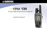
사용자 설명서차례Introduction3Getting to Know Your Rino 1307Front of the Rino 1308Back of the Rino 1309Main Display Pages10Operating the Rino 13011Status Bar Overview12Unit Operation13Radio Page13Initializing the Rino 13013Using My ID and Symbol Fields14Setting the Channel and Squelch Code16Scanning and Monitoring18Radio Page Option Menu20Setup Radio20Setup Tones22Setup Scanlist22Use Weather Radio23Turn Radio/GPS On/Off24Informational Picture24GPS Status24Radio Transmission Status24Mark Waypoint’s Indicators25Using the Rino 130 Radio Features26Peer-to-Peer Positioning26New Contact Page Overview26Sending a Location29Map Page30Map Page Options32Using the Pan Map Option33Programming the Data Fields34Setting up the Map35Measuring Distance37Navigation Page38Using the Navigation Page38Navigation Page Options40Using Sight ‘N Go41Calibrating the Compass41Altimeter Page43Altimeter Page Options44Viewing Pressure/Elevation Plots45Adjusting the Zoom Ranges45Viewing Points46Resetting Data46Calibrating the Altimeter47Programming Data Fields47Trip Computer Page48Trip Computer Page Options48Main Menu Page49Using the Main Menu49Main Menu Options51Shortcuts Menu52Waypoints53Mark Waypoint Page53Creating Waypoints54Projecting a Waypoint55Editing a Waypoint55Find ‘N Go57Finding a Waypoint58Finding a Contact60Finding a City61Finding an Exit62Finding a Point of Interest63Finding an Address or Intersection65Finding a Last Found Place67Weather Radio68Sending a Note69Using a Goto70Routes Page71Creating and Using a Route71Editing a Route72Adding or Editing from the Route Map Page75Navigating a Route76Stopping Navigation77Data Fields for the Route Page77Tracks Page78Using the TracBack Feature79Setting up the Track Log80Proximity Page81Satellite Page82Sky View Graphic82WAAS83Satellite Strength83Satellite Page Options84Setup Pages86Time Setup Page86Units Setup Page87LORAN TD Format88Display Setup Page89Heading Setup Page90Interface Setup Page91System Setup Page93Calendar94Alarm Clock96Calculator97Stopwatch98Stopwatch Lap Options98Sun & Moon99Hunt & Fish100Area Calculator101Games102Memory Race102Waypoint Bomber103Clothesline104Assimilation104Beast Hunt104Appendix105What is FRS?105FRS Features105FRS Limitations106GMRS106Specifications107Physical107Performance107Radio108Power108Accessories109Transferring MapSource Data110GPS Troubleshooting Guide112Radio Troubleshooting Guide113FRS Frequency Chart114Weather Radio Frequency Chart114GMRS Frequency Chart115Data Field Definitions116Interface Information118FCC Compliance Information119FCC Licensing Information120Limited Warranty121Software License Agreement123Product Registration123Contact Garmin123Warnings and Cautions124Index127크기: 1.27메가바이트페이지: 132Language: English매뉴얼 열기
사용자 매뉴얼차례Introduction3Getting to Know Your Rino 1307Front of the Rino 1308Back of the Rino 1309Main Display Pages10Operating the Rino 13011Status Bar Overview12Unit Operation13Radio Page13Initializing the Rino 13013Using My ID and Symbol Fields14Setting the Channel and Squelch Code16Scanning and Monitoring18Radio Page Option Menu20Setup Radio20Setup Tones22Setup Scanlist22Use Weather Radio23Turn Radio/GPS On/Off24Informational Picture24GPS Status24Radio Transmission Status24Mark Waypoint’s Indicators25Using the Rino 130 Radio Features26Peer-to-Peer Positioning26New Contact Page Overview26Sending a Location29Map Page30Map Page Options32Using the Pan Map Option33Programming the Data Fields34Setting up the Map35Measuring Distance37Navigation Page38Using the Navigation Page38Navigation Page Options40Using Sight ‘N Go41Calibrating the Compass41Altimeter Page43Altimeter Page Options44Viewing Pressure/Elevation Plots45Adjusting the Zoom Ranges45Viewing Points46Resetting Data46Calibrating the Altimeter47Programming Data Fields47Trip Computer Page48Trip Computer Page Options48Main Menu Page49Using the Main Menu49Main Menu Options51Shortcuts Menu52Waypoints53Mark Waypoint Page53Creating Waypoints54Projecting a Waypoint55Editing a Waypoint55Find ‘N Go57Finding a Waypoint58Finding a Contact60Finding a City61Finding an Exit62Finding a Point of Interest63Finding an Address or Intersection65Finding a Last Found Place67Weather Radio68Sending a Note69Using a Goto70Routes Page71Creating and Using a Route71Editing a Route72Adding or Editing from the Route Map Page75Navigating a Route76Stopping Navigation77Data Fields for the Route Page77Tracks Page78Using the TracBack Feature79Setting up the Track Log80Proximity Page81Satellite Page82Sky View Graphic82WAAS83Satellite Strength83Satellite Page Options84Setup Pages86Time Setup Page86Units Setup Page87LORAN TD Format88Display Setup Page89Heading Setup Page90Interface Setup Page91System Setup Page93Calendar94Alarm Clock96Calculator97Stopwatch98Stopwatch Lap Options98Sun & Moon99Hunt & Fish100Area Calculator101Games102Memory Race102Waypoint Bomber103Clothesline104Assimilation104Beast Hunt104Appendix105What is FRS?105FRS Features105FRS Limitations106GMRS106Specifications107Physical107Performance107Radio108Power108Accessories109Transferring MapSource Data110GPS Troubleshooting Guide112Radio Troubleshooting Guide113FRS Frequency Chart114Weather Radio Frequency Chart114GMRS Frequency Chart115Data Field Definitions116Interface Information118FCC Compliance Information119FCC Licensing Information120Limited Warranty121Software License Agreement123Product Registration123Contact Garmin123Warnings and Cautions124Index127크기: 1.2메가바이트페이지: 132Language: English매뉴얼 열기
사용자 매뉴얼차례Initializing the Receiver/Getting Started1Section 1: GPSMAP Status Page17Section 2: Position Page20Section 3: Map Page22Section 4: Navigation Page30Section 5: Main Menu Page33Section 6: Waypoints34Section 7: GOTO/MOB/TracBack Functions43Section 8: Routes47Section 9: Setup Menus55Section 10: Using G-chart cartridges65크기: 849킬로바이트페이지: 94Language: English매뉴얼 열기