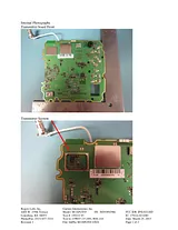
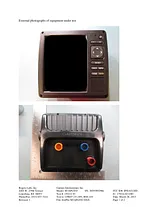
사용자 설명서차례Table of Contents3Introduction7Device Views7echoMAP 70 Series and GPSMAP 700 Series7Using the Touchscreen7Locking the Touchscreen7echoMAP 50 Series and GPSMAP 500 Series7Device Keys7Tips and Shortcuts7GPS Satellite Signals7Adjusting the Backlight7Adjusting the Color Mode7Customizing the Home Screen7Inserting Memory Cards8Charts and 3D Chart Views8Navigation Chart and Offshore Fishing Chart8Zooming In and Out of the Chart8Panning the Chart8Selecting an Item on the Map Using the Device Keys8Chart Symbols8Navigating to a Point on the Chart9Viewing Location and Object Information on a Chart9Viewing Details about Navaids9Premium Charts9Viewing Tide Station Information9Animated Tide and Current Indicators10Showing and Configuring Tides and Currents10Showing Satellite Imagery on the Navigation Chart10Viewing Aerial Photos of Landmarks10Automatic Identification System10AIS Targeting Symbols10Heading and Projected Course of Activated AIS Targets11Showing AIS Vessels on a Chart or 3D Chart View11Activating a Target for an AIS Vessel11Viewing Information about a Targeted AIS Vessel11Deactivating a Target for an AIS Vessel11Viewing a List of AIS Threats11Setting a Safe-Zone Collision Alarm11AIS Search and Rescue Transmitters11Navigating to a SART Transmission12AIS-SART Targeting Symbols12Enabling AIS Transmission Test Alerts12Turning Off AIS Reception12Chart and 3D Chart View Settings12Navigation and Fishing Chart Setup12Waypoints and Tracks Settings on the Charts and Chart Views12Overlay Numbers Settings12Editing the Data Fields12Showing a Navigation Inset13Chart Appearance Settings13Other Vessels Settings on the Charts and Chart Views13AIS Display Settings13Fish Eye 3D Settings13Navigation with a Chartplotter13Basic Navigation Questions14Destinations14Searching for a Destination by Name14Selecting a Destination Using the Navigation Chart14Searching for a Destination Using Nav Info14Searching for a Marine Services Destination14Courses14Setting and Following a Direct Course Using Go To14Setting and Following a Course Using Auto Guidance15Autopilot Navigation15Stopping Navigation15Waypoints15Marking Your Present Location as a Waypoint15Creating a Waypoint at a Different Location15Marking and Navigating to an MOB Location15Viewing a List of all Waypoints15Editing a Saved Waypoint15Moving a Saved Waypoint15Browsing for and Navigating to a Saved Waypoint15Deleting a Waypoint or an MOB16Deleting All Waypoints16Routes16Creating and Navigating a Route From Your Present Location16Creating and Saving a Route16Viewing a List of Routes16Editing a Saved Route16Browsing for and Navigating a Saved Route16Browsing for and Navigating Parallel to a Saved Route16Deleting a Saved Route17Deleting All Saved Routes17Tracks17Showing Tracks17Setting the Color of the Active Track17Saving the Active Track17Viewing a List of Saved Tracks17Editing a Saved Track17Saving a Track as a Route17Browsing for and Navigating a Recorded Track17Deleting a Saved Track17Deleting All Saved Tracks17Retracing the Active Track17Clearing the Active Track17Managing the Track Log Memory During Recording17Configuring the Recording Interval of the Track Log17Deleting All Saved Waypoints, Routes, and Tracks18Combinations18Selecting a Combination18Customizing the Combinations Screen18Gauges and Almanac Information18Viewing the Compass18Viewing Trip Gauges18Resetting Trip Gauges18Viewing Engine and Fuel Gauges18Customizing Engine Gauge and Fuel Gauge Limits18Enabling Status Alarms for Engine Gauges18Enabling Some Engine Gauge Status Alarms18Selecting the Number of Engines Shown in Gauges18Customizing the Engines Shown in Gauges19Configuring the Fuel Gauges Display19Setting the Fuel Capacity of the Vessel19Synchronizing the Fuel Data with the Actual Vessel Fuel19Setting the Fuel Alarm19Viewing the Wind Gauges19Configuring the Speed Source19Configuring the Heading Source of the Wind Gauge19Selecting the Range of the Close-Hauled Wind Gauge19Viewing the Environment Gauges19Configuring the Alignment of the Wind Gauge19Selecting the Range of the Close-Hauled Environment Gauge19Setting the Barometer Reference Time19Tide, Current, and Celestial Information20Tide Station Information20Current Station Information20Celestial Information20Viewing Tide Station, Current Station, or Celestial Information for a Different Date20Viewing Information for a Different Tide or Current Station20Viewing Almanac Information from the Navigation Chart20Sonar20Full-Screen Sonar View20Split-Zoom Sonar View20Split-Frequency Sonar View20Pausing the Sonar Display20Creating a Waypoint on the Sonar Screen20Adjusting the Gain on the Sonar Screen20Adjusting the Range of the Depth Scale20Setting the Zoom Level on the Sonar Screen21Selecting Frequencies21Turning On the A-Scope21Sonar Setup21Sonar Settings21Sonar Appearance Settings21Advanced Sonar Settings21Sonar Alarm Settings21Setting the Keel Offset21Recording the Sonar Display22Stopping the Sonar Recording22Depth and Water Temperature Graphs22Setting the Depth and Water Temperature Graph Range and Time Scales22Radar22Radar Display Modes22Transmitting Radar Signals22Adjusting the Zoom Scale on the Radar Screen23Tips for Selecting a Radar Zoom Scale23Sentry Mode23Enabling Timed Transmit23Setting the Standby and Transmit Times23Enabling a Guard Zone23Defining a Circular Guard Zone23Defining a Partial Guard Zone23Marking a Waypoint on the Radar Screen23Viewing a List of AIS Threats23Showing AIS Vessels on the Radar Screen23VRM and EBL24Showing the VRM and the EBL24Adjusting the VRM and the EBL24Measuring the Range and Bearing to a Target Object24Radar Overlay24Radar Overlay and Chart Data Alignment24Showing the Radar Overlay24Stopping the Transmission of Radar Signals24Optimizing the Radar Display24Range of Radar Signals24Radar Gain and Clutter24Automatically Adjusting Gain on the Radar Screen24Manually Adjusting Gain on the Radar Screen25Minimizing Nearby Large-Object Interference25Minimizing Side-Lobe Interference on the Radar Screen25Adjusting Sea Clutter on the Radar Screen25Adjusting Rain Clutter on the Radar Screen25Adjusting Cross Talk Clutter on the Radar Screen25Radar Display Settings25Radar Appearance Settings25Front-of-Boat Offset26Measuring the Potential Front-of-Boat Offset26Setting the Front-of-Boat Offset26Digital Selective Calling26Networked Chartplotter and VHF Radio Functionality26Turning On DSC26DSC List26Viewing the DSC List26Adding a DSC Contact26Incoming Distress Calls26Navigating to a Vessel in Distress26Man-Overboard Distress Calls Initiated from a VHF Radio26Man-Overboard Distress Calls Initiated from the Chartplotter26Position Tracking27Viewing a Position Report27Navigating to a Tracked Vessel27Creating a Waypoint at the Position of a Tracked Vessel27Editing Information in a Position Report27Deleting a Position-Report Call27Viewing Vessel Trails on the Chart27Individual Routine Calls27Selecting a DSC Channel27Making an Individual Routine Call27Making an Individual Routine Call to an AIS Target27Viewing Video27Selecting a Video Source27Configuring the Video Appearance28Configuring the VGA Display28Exiting VGA Display Mode28SiriusXM™28SiriusXM Equipment and Subscription Requirements28Weather Data Broadcasts28Viewing Precipitation Information28Precipitation Views28Switching Weather Charts29Storm Cell and Lightning Information29Hurricane Information29Weather Warnings and Weather Bulletins29Forecast Information29Viewing Forecast Information for Another Time Period29Viewing a Marine Forecast or an Offshore Forecast29Weather Fronts and Pressure Centers29City Forecasts30Viewing Sea Conditions30Surface Winds30Wave Height, Wave Period, and Wave Direction30Viewing Forecast Sea Conditions Information for Another Time Period30Viewing Fishing Information30Surface Pressure and Water Temperature Data30Forecasting Fish Locations30Visibility Information31Viewing Forecast Visibility Information for Another Time Period31Viewing Buoy Reports31Viewing Local Weather Information near a Buoy31Creating a Waypoint on a Weather Chart31Weather Overlay31Turning On the Weather Overlay on a Chart31Weather Overlay Settings on the Navigation Chart31Weather Overlay Settings on the Fishing Chart31Showing Fish Forecasting Data on the Fishing Chart31Viewing Weather Subscription Information31SiriusXM Radio32Customizing the Channel Guide32SiriusXM Presets32Saving a SiriusXM Channel to the Presets List32Adjusting SiriusXM Satellite Radio Volume32Changing the SiriusXM Settings from a Chart32Device Configuration32Turning On the Chartplotter Automatically32System Settings32GPS Settings32Viewing the Event Log32Viewing System Software Information32My Vessel Information32Setting the Keel Offset33Calibrating a Water Speed Device33Setting the Water Temperature Offset33Communications Settings33NMEA 2000 and NMEA 018333NMEA 018333NMEA 0183 Settings34NMEA 200034Viewing a List of NMEA 2000 Network Devices34Communication with Wireless Devices34Connecting a Bluetooth Wireless Device34Disconnecting a Bluetooth Wireless Device34Setting Up the Wireless Network34Connecting a Wireless Device to the Chartplotter34Setting Alarms34Navigation Alarms34System Alarms34Setting the Fuel Alarm34Setting Weather Alarms34Setting the Safe-Zone Collision Alarm34Units Settings35Navigation Settings35Auto Guidance Line Configurations35Adjusting the Distance from Shore35Other Vessel Settings36Viewing System Software Information36Restoring the Original Chartplotter Factory Settings36Chartplotter Data Management36Copying Waypoints, Routes, and Tracks to a Chartplotter36Copying Data from a Memory Card36Copying Waypoints, Routes, and Tracks to a Memory Card36Copying Waypoints, Routes, and Tracks to or from all Chartplotters on a NMEA 2000 Network36Copying Built-In Maps to a Memory Card37Backing Up Data to a Computer37Restoring Backup Data to a Chartplotter37Saving System Information to a Memory Card37Appendix37Registering Your Device37Calibrating the Touchscreen37Updating the Device Software37Screenshots37Capturing Screenshots37Copying Screenshots to a Computer37NMEA 0183 Information38NMEA 2000 PGN Information38Index39크기: 2.63메가바이트페이지: 44Language: English매뉴얼 열기